
The Great Arctic Cyclone August 2012
The next two weeks will determine where this year’s minimum will rank compared to recent years. And much will depend upon storm activity which breaks up ice edges, compacts ice chunks and transports ice out through Fram Strait where it melts in the warmer Norwegian Sea.
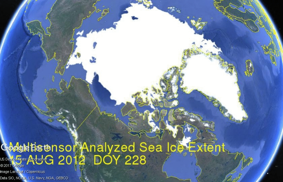
We have two recent examples in 2012 and 2016. The Great Arctic Cyclone of 2012 produced the lowest minimum of the decade. The NASA photo of the storm is above. The image below presents the impact of the 2012 storm upon ice extents from mid-August to mid-September annual minimum. (Click on image to enlarge.)
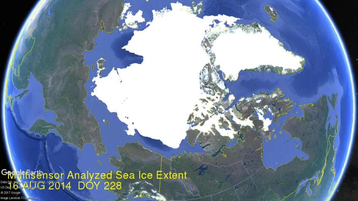
In contrast, a more normal, non-stormy year is represented by 2014. Progression of ice extents for 2014 is shown below.
Then again in 2016 several sizable Arctic storms struck late August. The image below shows cyclonic winds (center left) over the Arctic Ocean on August 22, 2016.

The storms effect on 2016 sea ice appears in the image below.

Summary
Arctic ice extents these three years were not far apart mid-August, but they ended the melt season quite differently. The Great Arctic Cyclone made 2012 the lowest of the decade, bottoming out at 3.4M km2. 2016 August storms also produced a low annual minimum of 4.2M km2. In contrast, the absence of major storms in 2014 resulted in a much higher September minimum of 5.13M km2. All of these compare to 2007 minimum of 4.05M km2, with no major storms reported.
It is difficult to extract a climate signal out of fluctuating ice extent minimums when they are so dependent on the vagaries of weather events. It also means that anything can happen in the next few weeks.

Beautiful work, Ron! I have taken to calling these storms “Gustogales” (short for August Gales). I am working on a second post about them. What really fascinated me was a 2013 gale that really shattered the ice, but the ice failed to melt. Maybe it was because the gale was tighter, (smaller), but I tend to think it was because the gale in 2012 chilled the water.
If I can get my act together I’ll send you some pictures concerning the 2013 gale. (Of course “getting my act together” is unlikely, according to those who know the state of my desk.)
Not to be critical, but there was a “Gustogale” in 2014, on August 30, but, as you superbly demonstrate, it too failed to melt much ice. Perhaps the water was still colder.
I’ve seen mention of a short four to five year cycle that might be involved, involving SST and sea ice, but haven’t seen a good discussion of the supposed short-cycle.
Anyway, thanks again for this post. I really admire the way you gather and display facts.
LikeLike
Hi again Ron,
I stayed up late and did manage to “get my act together.” Here are some visuals you might like to add to your collection:
With thanks to Ryan Maue, the moisture inflow to the 2013 August arctric gale:
With thanks to Danish Meteorological Institute, map of that gale:
https://sunriseswansong.files.wordpress.com/2017/08/gusta-5-dmi-aug-8-pressure-mslp_latest-big.png?w=426&h=593
With thanks to Tony Hellar, smashed up sea-ice after that gale:
The intriguing thing is that the sea-ice did not melt to the extent it did in 2012.
Keep fighting the good fight!
LikeLike
Thanks Caleb for that information and reflections. You have been noticing and thinking on August Arctic storms much longer than I. Only recently someone commented on the two 2016 storms, and I got the idea for this post.
I have long maintained that ice extents are mainly a function of the three Ws: Water, Wind and Weather. Both Water temps and salinity affect the ice. Wind circulation regimes change where the sea ice moves and whether it compacts or melts. And as we see here, Weather events have dramatic effects on the September minimum.
LikeLike
Caleb, I was also struck by this comment from Frederick Colbourne.
In salty ambient conditions, dissolution rather than melting often causes the ablation of ice. E.g. the temperature of the Arctic Ocean is generally below the melting point of ablating sea ice. The phase transition from solid to liquid is achieved by mixing salt and water molecules, similar to the dissolution of sugar in water, even though the water temperature is far below the melting point of the sugar. Hence dissolution is rate limited by salt transport whereas melting can occur at much higher rates that are characteristic for heat transport.[36]
https://en.wikipedia.org/wiki/Ice#Ablation
[36] Woods, Andrew W. “Melting and dissolving”. J. Fluid Mech. 239: 429–448. doi:10.1017/S0022112092004476.
Translating this into plain English: Arctic ice is not melting, but dissolving. The reason is that currents are bringing salty water into the Arctic.
Since my Earth science supervisor was a geologist, I picked up his habit of looking at the big picture and thus found the following paper useful for perspective. On the second page we read,
“Under the influence of winds and ocean currents, the Arctic sea-ice cover is in nearly constant motion. The large-scale circulation principally consists of the Beaufort Gyre, a mean annual clockwise motion in the western Arctic Ocean with a drift speed of [1 to 3 cm/s], and the Transpolar Drift, the movement of ice from the coast of Siberia eastward across the pole and into the North Atlantic by way of Fram Strait (Fig. 1). Ice velocities in the Transpolar Drift increase toward Fram Strait, where the mean drift speed is [5 to 20 cm/s] (Thorndike, 1986; Gow and Tucker, 1987).
About 20% of the total ice area of the Arctic Ocean and nearly all of the annual ice export is discharged each year through Fram Strait, the majority of which is multi-year ice….”
Polyak et al. History of sea ice in the Arctic, Quaternary Science Reviews xxx (2010) 1–22, 2010.
Click to access Polyak%20etal%20seaice%20QSR10%20inpress.pdf
Read it again:
“About 20% of the total ice area of the Arctic Ocean and nearly all of the annual ice export is discharged each year through Fram Strait, the majority of which is multi-year ice….”
Arctic ice is melting, it’s just not melting while in the Arctic.
PS: I had to look up “ablating”. It means eroding or wearing away.
LikeLiked by 1 person
Thanks for all this information, Ron. I’m going to sit and see if I can wrap my mind around it.
Salinity makes it possible for warmer water to be heavier than colder water, and sometimes a warmer layer slides into the arctic sea like a card into a deck, below colder, fresher water. I think these arctic gales mix up the water, and at first, while the warmer and saltier water is available, the ice melts. Then, when the water is “mixed”, less melting occurs. Just an idea.
LikeLike
Thanks Caleb. I have yet to fully grasp the dynamics between the warm incoming salty water and the cold fresh meltwater. This image from WHOI shows how fresh water sits on top and protects the ice from salty water.

But as you say, the situation is not static. WHOI imagines it as a series of flywheels stratified by temperature and salinity.
https://rclutz.wordpress.com/2015/07/20/follow-the-water-arctic-ocean-flywheels/
LikeLiked by 1 person
Wow! Cool post! I missed that one. Will catch up.
The more I learn the more I marvel at the complexity.
One engineer pointed out to me I wasn’t considering viscosity, and then proceeded to show off his knowledge. I swiftly felt like a dunce.
Despite the seemingly hopeless complexity, I have a sense there may be a quite simple system of “flywheels”, and once we see it we’ll wonder how we were blind to it before. (Sort of like when the concept of “continental drift” first hit the mainstream.)
LikeLike
Since additional connections are coming to mind, let me add this one.
We note firstly the classic pattern of temperature cycles seen in all datasets featuring quality-controlled unadjusted data. The low in 1913, high in 1944, low in 1975, and high in 1998. Also evident are the matching El Nino years 1998, 2009 and 2016, indicating that what happens in the Pacific does not stay in the Pacific.
Most interesting are the periodic peaking of AMO in the 8 to 10 year time frame. The arrows indicate the peaks, which as Dilley describes produce a greater influx of warm Atlantic water under the Arctic ice. And as we know from historical records and naval ice charts, Arctic ice extents were indeed low in the 1930s, high in the 1970s, low in the 1990s and on a plateau presently.
https://rclutz.wordpress.com/2017/02/08/amo-atlantic-climate-pulse/
LikeLike
A nice informative post – one more facet of the problem that a tyro like myself wasn’t clear about. (Although I knew of cases of August storms in the Arctic including 2012, I didn’t think to consider it a general phenomenon.)
LikeLike
Thanks for commenting rw. I am just now getting into this issue more deeply. Note these comments from an Arctic storm expert, Ian Simmonds of Melbourne.
“We have analysed a very dramatic storm which was formed over Siberia on 2 August 2012, moved into the Arctic basin, and finally finished its days in the CAA at 18UTC 14 August, a remarkable 12¾ days after its formation. During its lifetime the central pressure of the storm dropped to 966.38 hPa, while the structural attributes of DsqP, R, and D attained their extrema of 4.91 hPa (deg. lat.)−2, 6.62 deg. lat., and 18.21 hPa, respectively.
As to the Arctic storm itself, our analysis shows it to be a truly remarkable one analysed over the 1979–2012 period covered by CFSR/CFSV2. Using our multiple-index approach (based on cyclone properties and longevity) we conclude that AS12 was the most extreme August Arctic cyclone (out of a population of 1618).
The plot shows that AS12 was at the tail of the distribution and, at 966.38 hPa, was the lowest in our record, beating the previous deepest (966.94 hPa) (for a storm at 06UTC 7 August 1995) by 0.56 hPa. The next lowest central pressure, 969.23 hPa, was associated with a cyclone at 06UTC 22 August 1991, followed by the fourth lowest storm central pressure in the earlier part of that month 00UTC 7 August 1991 (970.47 hPa).
In our cyclone analysis we also determine the lifetime of each system, expressed in terms of how many (6 hourly) synoptic times the system was found in the Arctic basin. Figure 4e shows the August climatology of these, with about one half of all systems spending between 1 and 3 days in the basin.
When all Arctic cyclones were considered (which included the more vigorous winter systems) AS12 ranked in position 13 out of a compilation of 19625 storms. This storm truly deserves the title of ‘The Great Arctic Cyclone of August 2012’.
http://onlinelibrary.wiley.com/doi/10.1029/2012GL054259/full
LikeLike